Affiliate link: we earn a commission.
📌Department
La Libertad (El Salvador). Joya de Cerén is a Maya archaeological site in the municipality of San Juan Opico, northwest of San Salvador, in the Zapotitán valley. It's known as the 'Pompeii of the Americas' because a Maya farming village was buried and preserved by the ash of a volcanic eruption around the 7th century AD. It's the only UNESCO World Heritage Site in El Salvador (inscribed in 1993, site no. 675) and it offers a unique window into the everyday life of ordinary Maya people
📌Service city
Joya de Cerén is about 35-40 km from San Salvador, near the road toward Santa Ana, in the Zapotitán valley. The service base is San Salvador (hotels, hospitals, banks) and, closer by, the towns of San Juan Opico and Santa Tecla. The site has a site museum, a visitor center and parking. It's usually visited together with the nearby archaeological site of San Andrés, also in the Zapotitán valley
📌Best time to visit
The dry season (November to April) is the best time to visit Joya de Cerén, with sunny days and roads in good condition. The rainy season (May to October) can bring afternoon showers; it's best to visit in the morning. The site is toured outdoors, with the structures protected under roofs, so it's worth going early to avoid the midday heat
📌Hours
Open Tuesday to Sunday, from 9:00 to 16:00; closed on Mondays (Ministry of Culture hours; check when you visit, as they can change on holidays). The site museum keeps the same hours
📌Currency
US dollar (USD), legal tender in El Salvador. Bring cash in small bills for the entrance, parking, guides and tips; there isn't always a card terminal at these sites
📌Suggested days
A visit to Joya de Cerén takes half a day (between 1 and 2 hours at the site and the museum). It's common to combine it with the nearby archaeological site of San Andrés, in the same Zapotitán valley, to make up an archaeological tour of half a day to a full day. Both work very well as an excursion from San Salvador, and they can be chained with a stop in Santa Tecla or on the Ruta de las Flores / Santa Ana if you continue west
💱 USD exchange rate
Loading rate…
🌤️ Weather in Joya de Cerén
Joya de Cerén is one of the most fascinating archaeological sites in all of the Americas and El Salvador's heritage jewel: the only place in the country declared a World Heritage Site by UNESCO. But what makes it unique in the world isn't great pyramids or monumental temples — it's the exact opposite: here, buried under the ash of a volcanic eruption, a humble 7th-century Maya farming village was preserved, with its houses, its kitchens, its gardens and even the remains of the food its inhabitants left behind as they fled.
That's why it's known as the 'Pompeii of the Americas'. While most Maya sites tell us the story of kings, priests and elites, Joya de Cerén shows us the everyday life of ordinary people: what their adobe dwellings were like, what they grew, how they cooked, how they stored their belongings. The volcanic ash sealed and preserved everything in an extraordinary way, offering an unrepeatable snapshot of Mesoamerican farming life more than one thousand three hundred years ago.
This guide covers Joya de Cerén with a practical, warm eye: exactly what you see at the site, why it matters so much, how to combine it with nearby San Andrés, how to get there from San Salvador and what to keep in mind for the visit. It's an essential stop for anyone who wants to understand the Maya root of El Salvador and marvel at one of the most astonishing time capsules on the continent.
📖 History of Joya de Cerén
Joya de Cerén was a small Maya farming village in the fertile Zapotitán valley, an area inhabited and cultivated since pre-Hispanic times. Around the year 600 AD (7th century), the eruption of the nearby Loma Caldera volcano suddenly covered the village with several layers of volcanic ash. The inhabitants managed to flee —no human remains have been found in the structures—, but they left almost everything behind, and the ash sealed and preserved the adobe buildings, the utensils, the food and even the traces of the crops with an exceptional degree of detail, something practically unique in Mesoamerican archaeology. The site remained buried and forgotten for more than a thousand years. It was discovered by chance in 1976, when land-leveling work with machinery brought ancient structures to light; the archaeological excavations that followed, led by researchers who studied the site in depth, revealed its extraordinary value. In 1993, UNESCO inscribed Joya de Cerén on the World Heritage List (site no. 675), recognizing it as an exceptional testament to the everyday life of a Mesoamerican farming community. It's the only Salvadoran site with that distinction. Its importance lies precisely in what it preserves: not elite monuments, but the dwellings, kitchens, workshops, storerooms and fields of a community of ordinary farmers, which makes it an irreplaceable source for learning how people in the Maya world really lived. The full history is on our history page.
Read the full history ↓🏛️ Joya de Cerén is in la Libertad
The surfing coast of El Salvador: the Costa del Bálsamo with El Tunco, El Sunzal and El Zonte —the 'Bitcoin Beach'—, heart of the 'Surf City' project, plus the Maya ruins of Joya de Cerén and San Andrés, the garden city of Santa Tecla and the El Boquerón crater of the San Salvador volcano.
Read the history of La Libertad →🗺️ What to see
Tours nearby, in San Salvador
If you only have one day, take a guided tour on the first one: it sets up the rest of your trip and saves you a lot of walking. We look ours up on Civitatis: guided in Spanish and booked online with no fuss. They have 10 activities in San Salvador. And there are free tours here: you book without paying and tip the guide whatever you think at the end, so trying one costs you nothing. Have a look below: tap any of them to see them all.
They depart from San Salvador, 23 km away. Affiliate link: we earn a commission.
1
The structures of the Maya village
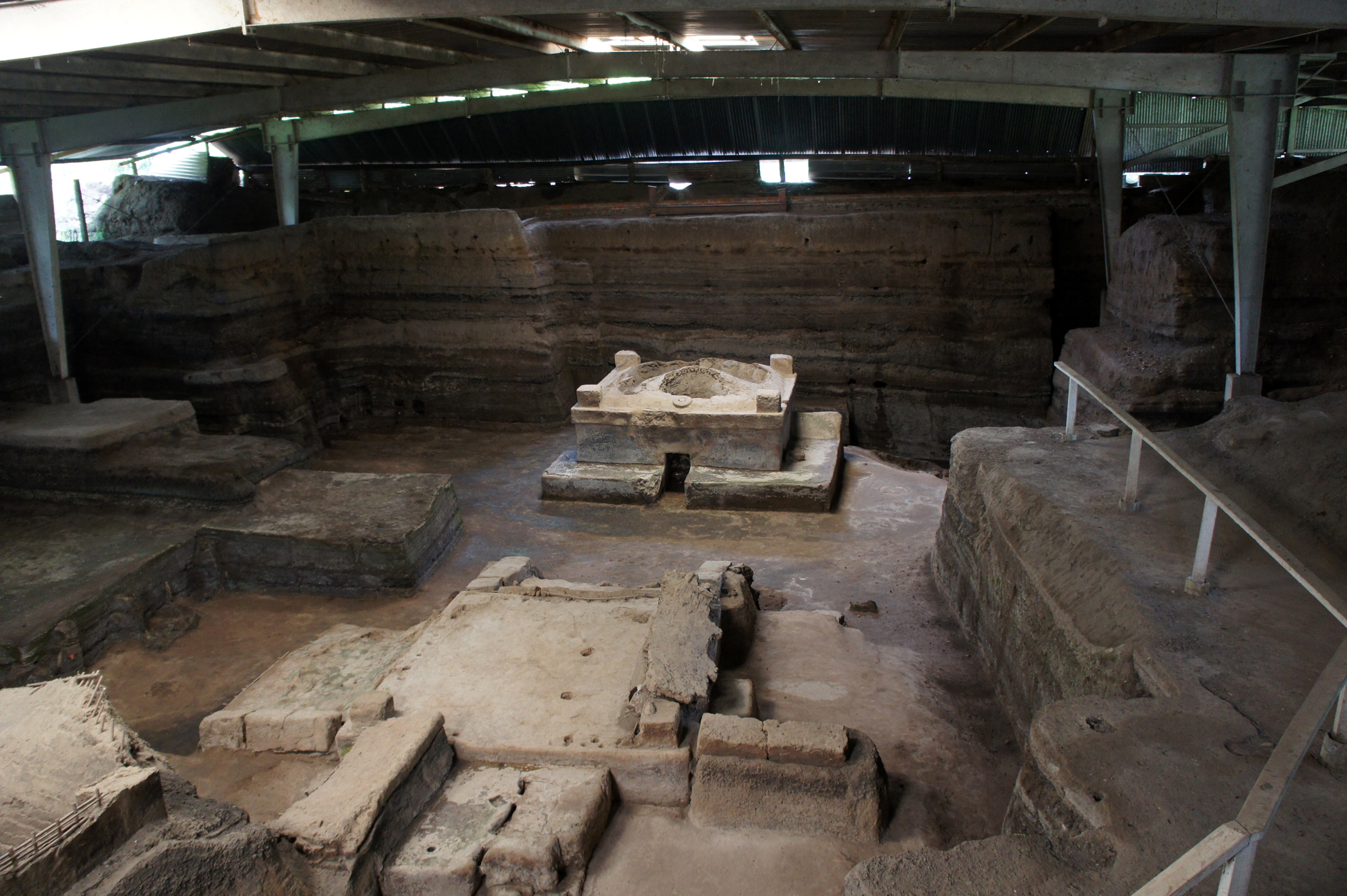
The remains of the houses, kitchens, storerooms and buildings of the Maya farming village, preserved under protective roofs.
Read more ↓
The heart of a visit to Joya de Cerén is the structures of the Maya village that the volcanic ash preserved more than one thousand three hundred years ago. Unlike other archaeological sites dominated by stone pyramids, what you see here are buildings of adobe and bahareque (mud and plant materials), the real dwellings and everyday buildings of a community of farmers, something extremely rare to find preserved in the Maya world.
Among the excavated structures protected under large roofs you can make out dwellings (the spaces where people slept and lived), kitchens with their hearths and utensils, storerooms where they kept grain and belongings, workshops and other buildings with various functions. Different complexes or 'structures' numbered by the archaeologists have been identified, each with its role in the life of the village. The ash preserved walls, floors, pots, vessels, tools and even remains of food and crops, which allowed researchers to reconstruct daily life in astonishing detail.
Walking the walkways that surround these structures is like looking into a village frozen in time, at the precise moment its inhabitants abandoned it. The interpretive signs and the guide help you picture the life that went on there.
ℹ️ Distance: Inside the archaeological site of Joya de Cerén (San Juan Opico, Zapotitán valley) · Best time: In the morning, to avoid the heat; in the dry season (Nov-Apr) · Admission: Included in the site entrance (US$ 3 foreigners / US$ 2 Central Americans / US$ 1 Salvadorans; verified July 2026) · Duration: 1 to 2 hours (site and museum)
2
Joya de Cerén site museum
The museum that exhibits the pieces found and explains the discovery and the value of the site.
Read more ↓
The Joya de Cerén site museum is the best introduction to the visit, and it's worth going through it before heading out to see the structures, so you understand what you're looking at and why this place is so exceptional. It gathers pieces and materials found in the excavations —ceramics, utensils, tools and other objects from the village's everyday life— and explains the site's story through panels, models and reproductions.
The museum covers what the village was like before the eruption, how the Loma Caldera volcano buried it around the 7th century, how the site was discovered by chance in 1976 and how archaeologists managed, from the ash, to reconstruct the life of its inhabitants in such detail. It also explains the unique value of Joya de Cerén as a testament to the life of ordinary Maya people, in contrast to sites centered on the elites, and its recognition as a UNESCO World Heritage Site.
It's a museum sized to match the site, informative and useful for giving context. The combination of museum and outdoor tour makes the visit complete and understandable even for non-specialists.
ℹ️ Distance: Within the archaeological site grounds, next to the visitor center · Best time: Tuesday to Sunday (closed Monday) · Admission: Included in the site entrance (US$ 1–3 depending on origin; verified July 2026) · Duration: 30 to 45 minutes
3
The nearby Maya ceremonial center of the Zapotitán valley, with pyramids and a museum, ideal to combine with Joya de Cerén.
Read more ↓
A few kilometers from Joya de Cerén, in the same Zapotitán valley, is the archaeological site of San Andrés, which complements the visit perfectly and gives you a fuller picture of the Maya world in El Salvador. If Joya de Cerén shows the everyday life of a farming village, San Andrés shows the other side: a ceremonial and political center with monumental architecture.
San Andrés was an important pre-Hispanic city that came to dominate the Zapotitán valley in the Maya Classic period. It preserves pyramidal structures and the plazas of a center of power, with platforms and mounds where religious and administrative functions were concentrated. The site also has a museum that exhibits pieces found there and explains the history of the place, including vestiges of the colonial era, since the area later held an indigo hacienda (indigo works).
The proximity and complementarity of the two sites make the Joya de Cerén + San Andrés combination the classic archaeological tour of the Zapotitán valley, highly recommended for understanding both ordinary life and power in the Salvadoran Maya world.
ℹ️ Distance: About 5–6 km from Joya de Cerén, in the Zapotitán valley (car, taxi/app or excursion) · Best time: In the morning and in the dry season (Nov-Apr) · Admission: Its own site entrance (US$ 3 foreigners / US$ 2 Central Americans / US$ 1 Salvadorans; verified July 2026) · Duration: 1 to 2 hours (combinable with Joya de Cerén)
4
The Zapotitán valley and its farmland
The fertile farming valley that surrounds the sites, key to understanding why Maya life flourished there.
Read more ↓
The Zapotitán valley, where Joya de Cerén and San Andrés sit, is an essential part of the story of these sites. It's a fertile plain watered by rivers and enriched by volcanic soils, which made it an ideal farming area from pre-Hispanic times on. That fertility explains why Maya life flourished here, with farming villages and centers of power.
At Joya de Cerén, in fact, the volcanic ash preserved even the traces of the crops —such as the rows of maize plants and other plantings—, which allowed archaeologists to know what the inhabitants grew and how. Touring the area and taking in today's farming landscape helps you picture that past and understand how closely those communities were tied to the land.
The same volcanic setting that gave the valley its fertility was also, paradoxically, what buried Joya de Cerén and preserved it for posterity. That duality —the land that gives life and the land that destroys— is a constant in the history of El Salvador, a country deeply marked by its volcanoes.
ℹ️ Distance: Surroundings of Joya de Cerén and San Andrés (Zapotitán valley) · Best time: Dry season (Nov-Apr) · Admission: Free (the surrounding landscape; the attractions are the archaeological sites) · Duration: A complement to the visit to the sites
5
The great archaeological complex of Chalchuapa, a little over an hour away, to extend the Maya route.
Read more ↓
For anyone who wants to go deeper into Salvadoran archaeology, the Chalchuapa complex, in the department of Santa Ana, is a little over an hour from Joya de Cerén heading west. There you'll find Tazumal, one of the largest and best-preserved pre-Hispanic structures in El Salvador, with an imposing stepped pyramid.
Chalchuapa was an important center of the Maya culture and its predecessors, with thousands of years of occupation, and it also takes in other sites such as Casa Blanca and El Trapiche. Tazumal has a site museum and is one of the most visited places in the country. Admission follows the Ministry of Culture scheme, with a fee that varies by origin (approx. US$ 1–3; verified July 2026).
Chaining Joya de Cerén and San Andrés with Tazumal lets you put together a complete archaeological route through western El Salvador in one or two days, combinable with the Ruta de las Flores and the city of Santa Ana.
ℹ️ Distance: A little over 1 h to the west (Chalchuapa, Santa Ana) · Best time: In the morning; Tuesday to Sunday (check) · Admission: US$ 1–3 depending on origin (Ministry of Culture scheme; verified July 2026) · Duration: 1 to 2 hours (site and museum)
6
A stop on the way back with dining, the Paseo del Carmen and the volcano lookout (El Boquerón).
Read more ↓
On the way back from Joya de Cerén toward the capital, Santa Tecla is an excellent stop. Its Paseo El Carmen is a pedestrian street full of restaurants, bars, galleries and nightlife, ideal for lunch or dinner after the archaeological visit. The city has a pleasant climate and a lively cultural scene.
Very close by is El Boquerón National Park, at the summit of the San Salvador volcano, with a trail along the rim of the enormous crater and panoramic views. Admission to the park is very cheap (approx. US$ 1–3; verified July 2026) and it pairs well with the archaeological day to close things out with nature and scenery.
This combination —Maya sites in the morning, food in Santa Tecla and sunset at the volcano— is one of the most complete day plans around San Salvador.
ℹ️ Distance: Santa Tecla about 25–30 min from the sites; El Boquerón a bit farther up · Best time: Afternoon for Paseo El Carmen; morning or a clear afternoon for El Boquerón · Admission: Santa Tecla free; El Boquerón Park approx. US$ 1–3 (verified July 2026) · Duration: Half a day (complement)
🛡️ Getting sick far from home shouldn't cost you thousands of USD
Abroad, getting sick is more than a bad day. In many destinations public healthcare depends on appointments, queues and availability, and private care is paid upfront. An emergency can cost thousands of USD, right when you are far from home and on a tight budget. That is why I recommend you never leave without travel assistance.
I recommend GO! Assistance because it covers what matters: medical care, emergencies, medication and hospitalization depending on the plan. It protects you 24 hours a day, anywhere in the world, with real-time solutions on the ground. GO! 365 ECO and GO! 365 give you USD 45,000 of global coverage: the first with a USD 100 deductible, the second with none.
If you quote from Argentina, in October GO! also offers 12 interest-free instalments on all its products.
An emergency abroad can cost thousands of dollars. Travel with assistance.
GO! Assistance has 50% off in October and, with our link, you get an extra 20%.
Pick origin, destination, dates and ages and see the price of your travel assistance in a minute.
📶 Internet from the moment you land
I have never been left without internet on a trip. I land and my phone connects to the strongest network in the country I am visiting: I can let people know I arrived, sort out transport, book tours and keep posting content at a super affordable price (really cheap!). I always use the Maya Mobile eSIM, check out its plans by clicking the banner. See Maya Mobile plans →
Affiliate link: we earn a commission.


💵 Prices
Tickets
| Type | Price |
|---|
| Joya de Cerén archaeological site (includes the site museum) — foreigners (rest of the world) | US$ 3 per person (source: Ministry of Culture rate; verified July 2026) |
| Joya de Cerén — Central American visitors | US$ 2 per person (verified July 2026, with ID) |
| Joya de Cerén — Salvadorans / residents | US$ 1 per person (verified July 2026, with ID) |
| Parking (per vehicle) | US$ 1,50 (verified July 2026) |
| San Andrés archaeological site (includes museum) | US$ 3 foreigners / US$ 2 Central Americans / US$ 1 Salvadorans (verified July 2026) |
| Local guide at the site (optional) | Tip / approx. US$ 5–15 per group depending on the tour (verified July 2026) |
🔄 updated monthlyOfficial / reference values · double-check when buying
Activities and tours
| Activity | Price | Duration | Operator |
|---|
| Guided visit to Joya de Cerén (the 'Pompeii of the Americas') | Entrance US$ 1–3 + guide approx. US$ 5–15 per group (verified July 2026) | 1-2 h | Site guides / Ministry of Culture |
| Combined archaeological tour Joya de Cerén + San Andrés | US$ 35–70 per person depending on the group (includes transport and guide; verified July 2026) | Half a day | San Salvador agencies |
| Day trip from San Salvador (Maya sites + Santa Tecla / El Boquerón) | US$ 45–90 per person depending on group and agency (verified July 2026) | Full day | Tour operators in the capital |
| Western archaeological route (Joya de Cerén + San Andrés + Tazumal) | US$ 60–120 per person with transport and guide (verified July 2026) | Full day | Tourism agencies |
🔄 updated monthlyOfficial / reference values · double-check when buying
🚌 How to get there and distances
Getting around
NotesThe most convenient way to reach the sites of the Zapotitán valley and combine them. There's parking at Joya de Cerén (US$ 1,50). To find your way use Google Maps or Waze, which work well across the metropolitan area and all the way to the site
Taxi / app (Uber, InDrive) from San Salvador or Santa Tecla
PriceUS$ 25–45 one way from San Salvador; more with waiting time (verified July 2026)
NotesUber, InDrive and DiDi operate in Greater San Salvador and reach the Zapotitán valley; you pay through the app (card) or in cash. It's worth arranging waiting time so you can visit both sites and return, since finding a ride back at the site is difficult
NotesThe most practical option for visitors: it includes transport and a guide, and it usually combines Joya de Cerén with San Andrés
Public bus toward San Juan Opico (route 108) + walk
PriceUS$ 0,45–1 per leg, paid IN CASH to the conductor (verified July 2026)
NotesCheap but not very practical: the buses leave from the Terminal de Occidente (San Salvador), you pay in cash (there's no card or QR on the interior routes) and you have to walk or take a moto-taxi from the highway to the site (about 15 min). Google Maps and Moovit help plan the leg from the capital, but real-time coverage outside the metropolitan area is limited
🔄 updated monthlyOfficial / reference values · double-check when buying
How to get there
| Route | Airlines / operators | Avg. price | Duration |
|---|
| From San Salvador → Joya de Cerén (car or taxi/app) | Private cars and taxis/apps | Taxi/app US$ 25–45 one way; fuel if it's your own car (verified July 2026) | Approx. 45 min to 1 h (about 35-40 km) |
| From Santa Tecla → Joya de Cerén | Taxis/apps and cars | Taxi/app US$ 18–30 one way (verified July 2026) | Approx. 30 to 45 min |
| Organized half-day / full-day excursion | San Salvador tourism agencies | US$ 35–90 per person depending on the program (verified July 2026) | Half a day to a full day |
| Public bus from the Terminal de Occidente (San Salvador) | Routes 108 / 201 toward San Juan Opico / Santa Ana | US$ 0,50–1,25 per leg (verified July 2026) | 1 to 1,5 h (with a transfer or a final walk) |
🔄 updated monthlyOfficial / reference values · double-check when buying
🏨 Where to stay
No exact prices: a scale from $ (budget) to $$$$$ (luxury), with 2-3 options per category.
Upmarket lodging in San Salvador (recommended base)
Recommended optionsUS$ 90–200 a night; chain and boutique hotels in the Zona Rosa / Escalón, ideal as a base for the excursion (verified July 2026)
Mid-range hotels in San Salvador or Santa Tecla
Recommended optionsUS$ 45–90 a night; mid-range hotels and B&Bs with a pleasant climate and good food, closer to the Zapotitán valley (verified July 2026)
Budget lodging and hostels (capital / Santa Ana)
Recommended optionsUS$ 15–45 a night; hostels and budget inns, useful if you combine this with a visit to the west of the country (verified July 2026)
🍴 Where to eat
Local eateries and pupuserías in the area (San Juan Opico)
Options / signature dishUS$ 1–6 per person; pupusas at about US$ 1, dish of the day and typical Salvadoran food at good prices
Restaurants in Santa Tecla (Paseo El Carmen)
Options / signature dishUS$ 8–20 per dish; a wide range of national and international cooking, bars and cafés on the pedestrian street
Options / signature dishUS$ 12–35 per dish; the capital offers the greatest variety, from typical cooking to fine dining and international cuisine
📖 History of Joya de Cerén
Origins, formation and what the sources say.
A Maya farming village in the Zapotitán valley
Before the catastrophe that would make it famous, Joya de Cerén was a small Maya farming village located in the Zapotitán valley, a fertile plain of present-day western El Salvador, watered by rivers and enriched by soils of volcanic origin. That fertility had attracted human communities since pre-Hispanic times, who found in the valley an ideal place to grow corn, beans, cacao, cotton and other products.
The inhabitants of Joya de Cerén were part of the Mesoamerican Maya world, but they weren't kings or priests: they were ordinary farmers, families who lived off the land. They dwelled in houses of adobe and bahareque (structures of mud and plant materials), worked their fields, stored grains in storerooms, cooked over hearths and took part in a community life about which we know a great deal today thanks to the preservation of the site.
This status as a village of ordinary people is precisely what makes Joya de Cerén so valuable. Most Maya archaeological sites tell us about the elites —their temples, their tombs, their inscriptions—, but very few preserve the everyday life of the peasant population, which was the vast majority. Joya de Cerén is an exceptional window into that usually invisible world.
The Zapotitán valley and pre-Hispanic agriculture
The sources describe the Zapotitán valley as a fertile area of volcanic soils, favorable for agriculture, where Maya communities developed. Joya de Cerén was one of those farming villages, inhabited by ordinary people dedicated to cultivation, within the Maya cultural sphere of the region.
Source: https://es.wikipedia.org/wiki/Joya_de_Cer%C3%A9n
The Loma Caldera eruption and the buried village (7th century)
Around the year 600 AD (7th century), the life of the village of Joya de Cerén was suddenly interrupted. The nearby Loma Caldera volcano erupted and covered the town with successive layers of volcanic ash that buried it completely. The eruption was sudden, but the evidence suggests that the inhabitants managed to sense the danger and flee: no human remains have been found within the structures, which indicates that the people escaped leaving behind their houses and belongings.
That hurried flight, combined with the way the ash covered the site, produced an extraordinary preservation effect. The ash sealed the adobe buildings, the utensils, the vessels, the stored food and even the traces of the crops in the fields, freezing the village at the precise instant it was abandoned. It's this circumstance that gave rise to the nickname 'Pompeii of the Americas', by analogy with the Roman city buried by Vesuvius.
The key difference from Pompeii, however, is hopeful: while there many inhabitants died, in Joya de Cerén everything indicates that the population managed to get to safety. What was left buried was not a human tragedy, but an intact snapshot of everyday life, preserved by the same volcano that forced its inhabitants to leave.
The dating of the eruption and the flight of the inhabitants
The sources place the eruption of the Loma Caldera volcano that buried Joya de Cerén around the year 600 AD (around the 7th century). The absence of human remains in the structures leads researchers to conclude that the inhabitants managed to flee. The precise datings are based on archaeological studies and may be adjusted with new research.
Source: https://whc.unesco.org/en/list/675/
The chance discovery of 1976
For more than a thousand years, Joya de Cerén remained buried under the ash, forgotten and invisible. Its rediscovery happened completely by chance in 1976, when land-leveling work with heavy machinery in the area brought ancient mud structures to light. What at first might have passed for unimportant remains turned out to be, after the intervention of specialists, an archaeological find of the first order.
The excavations that followed, led by archaeologists who studied the site in depth —among them the American researcher Payson Sheets, whose work is an obligatory reference—, gradually revealed the magnitude of what was preserved: dwellings, kitchens, storerooms, workshops, utensils, remains of food and traces of crops, all preserved by the ash in astonishing detail. The site began to be known and valued as a unique case in Mesoamerican archaeology.
The research at Joya de Cerén made it possible to reconstruct, as in few places, what the daily life of an ordinary Maya community was like: what they ate, how they cooked, how they organized their houses, what they grew and how they related to their environment. Each new excavation provided data that at other sites would be impossible to obtain, turning this humble village into a scientific source of incalculable value.
The 1976 find and the subsequent research
The sources agree that Joya de Cerén was discovered accidentally in 1976 during work with machinery. The subsequent scientific excavations, notably associated with the archaeologist Payson Sheets, revealed the exceptional state of preservation of the site and made it possible to study Maya everyday life in unusual detail.
Source: https://en.wikipedia.org/wiki/Joya_de_Cer%C3%A9n
UNESCO World Heritage Site (1993)
The exceptional value of Joya de Cerén was recognized worldwide in 1993, when UNESCO inscribed it on the World Heritage List as site number 675. It's the only property in El Salvador that holds this distinction, which makes it the country's main heritage treasure and a reference point for the archaeological heritage of all Mesoamerica.
UNESCO based the inscription on the site's unique character as a testament to the everyday life of a Mesoamerican farming community. Unlike the great Maya centers, known for their monumental architecture and their connection with the elites, Joya de Cerén offers a direct and detailed image of how ordinary people lived: their dwellings, their domestic activities, their agriculture. The preservation by volcanic ash preserved that information in a way that has practically no parallel.
That international recognition reinforced the protection of the site and its importance as a cultural and educational destination. Joya de Cerén became a point of national pride for El Salvador and an essential visit for those who want to understand the country's Indigenous roots and the life of the Maya world beyond the kings and the temples.
The outstanding universal value recognized by UNESCO
UNESCO inscribed Joya de Cerén in 1993 (site no. 675) for being an exceptional testament to the everyday life of a Mesoamerican farming community, preserved by volcanic ash. It's the only Salvadoran site on the World Heritage List.
Source: https://whc.unesco.org/en/list/675/
What it teaches us: Maya everyday life in detail
Beyond the dates and the recognitions, what's truly fascinating about Joya de Cerén is what it has taught us about the everyday life of the Maya world. Thanks to the preservation by ash, the archaeologists were able to reconstruct in unusual detail what the daily life of a farming village was like more than one thousand three hundred years ago, something that at most sites can only be surmised.
At Joya de Cerén different types of structures were identified according to their function: dwellings where people slept and kept their belongings, kitchens with hearths and utensils, storerooms for grains and belongings, and other buildings of communal or ritual use. Vessels, tools, domestic objects and even remains of prepared and stored food were found, which makes it possible to know what they ate and how. In the fields, the ash preserved the traces of the crops, showing the rows of corn and other crops just as they were on the day of the eruption.
All this information makes Joya de Cerén an irreplaceable source for archaeology. It makes it possible to study the economy, the diet, the domestic organization, the agriculture and the social life of an ordinary Maya community, complementing what other sites tell about the elites. Visiting Joya de Cerén is, in essence, a glimpse into the life of the ordinary people who sustained the Maya world, those who rarely appear in the great histories and who here were preserved forever.
❓ Frequently asked questions
How much does admission to Joya de Cerén cost?+
According to the Ministry of Culture rates (verified July 2026), admission costs US$ 1 for Salvadorans and residents, US$ 2 for Central American visitors and US$ 3 for tourists from the rest of the world, and it includes the site museum. Parking costs US$ 1,50 per vehicle. Bring cash in small bills and check the rates when you visit.
What days and hours is it open?+
It's open Tuesday to Sunday, from 9:00 to 16:00, and closed on Mondays. It's best to go in the morning to make the most of the light and avoid the heat, since part of the tour is outdoors (the structures are protected under roofs). Always check the hours and any changes on holidays.
Why is Joya de Cerén a UNESCO World Heritage Site?+
Because it's an exceptional and unique testament to the everyday life of a Maya farming community, preserved by volcanic ash around the 7th century AD. Unlike other Maya sites centered on elites, here the houses, kitchens, storerooms, utensils and even the crops of ordinary people were preserved. It was inscribed by UNESCO in 1993 (site no. 675) and it's the only World Heritage Site in El Salvador.
Why is it called the 'Pompeii of the Americas'?+
Because of the analogy with Pompeii, the Roman city buried by Vesuvius: just as there, at Joya de Cerén a volcanic eruption (that of the Loma Caldera volcano) covered and preserved the village in extraordinary detail, freezing the life of its inhabitants in time. The big difference is that no human remains were found at Joya de Cerén: the people managed to flee.
Is it worth combining it with San Andrés?+
Yes. The best plan is to combine Joya de Cerén with the nearby site of San Andrés (about 5–6 km away, in the same Zapotitán valley), to get a complete picture of the Salvadoran Maya world: ordinary life at Cerén and ceremonial power at San Andrés. Each costs US$ 1–3 depending on origin, and together they make a tour of half a day to a full day.
How do I get there from San Salvador?+
Joya de Cerén is about 35-40 km from the capital (45 minutes to 1 hour by car). You can go by your own or a rented car, by taxi/app (US$ 25–45 one way, ideally with waiting time so you can combine it with San Andrés) or on an organized excursion (US$ 35–90 per person), which is the most practical option and includes transport and a guide. By public bus it's cheaper but it requires transfers.
How do I get to Joya de Cerén and how do I pay for the bus?+
The most convenient options are your own car, a taxi or an app (Uber, InDrive and DiDi operate in Greater San Salvador and reach the Zapotitán valley, with payment by app or cash), or an organized excursion. By public bus it's cheaper but awkward: you take route 108 or 201 from the Terminal de Occidente in San Salvador and pay IN CASH to the conductor (US$ 0,45–1 per leg; on the interior routes there's no rechargeable card or QR), with a final walk or moto-taxi from the highway to the site. To find your way, Google Maps and Waze work well all the way to the site; Moovit helps plan the bus leg from the capital, though real-time location outside the metropolitan area is limited.
Do I need a guide to visit Joya de Cerén?+
It's not mandatory, but it's highly recommended: a guide (or joining a guided visit) helps enormously to understand what you're looking at, since the adobe structures can seem underwhelming at first glance if you don't know what they mean. The site museum, which is worth touring first, also gives you the context you need. A local guide runs about US$ 5–15 per group.
More places in El Salvador
Sources consulted (9)
- UNESCO — «Joya de Cerén Archaeological Site» (site no. 675): https://whc.unesco.org/en/list/675/
- Ministerio de Cultura — Parque Arqueológico Joya de Cerén: https://www.cultura.gob.sv/parque-arqueologico-joya-de-ceren/
- El Salvador Travel (official tourism site): https://elsalvador.travel/
- link out of service — the portal.cultura.gob.sv subdomain does not resolve (NXDOMAIN). The Ministry of Culture site is still up at https://www.cultura.gob.sv/ , but the Joya de Cerén rate has to be dug out there: no rate published in an official source (none verified). Verified on 08/08/2026
- Ideas Para Viajar — Joya de Cerén: precio entradas y horarios: https://ideasparaviajar.com/precio-entrada-sitio-arqueologico-joya-de-ceren
- Wikipedia (ES) — «Joya de Cerén»: https://es.wikipedia.org/wiki/Joya_de_Cer%C3%A9n
- Wikipedia (EN) — «Joya de Cerén»: https://en.wikipedia.org/wiki/Joya_de_Cer%C3%A9n
- Wikipedia (ES) — «San Andrés (archaeological site)»: https://es.wikipedia.org/wiki/San_Andr%C3%A9s_(sitio_arqueol%C3%B3gico)
- VisitCentroamerica — Sitio arqueológico San Andrés: https://www.visitcentroamerica.com/visitar/sitio-arqueologico-san-andres/